
Make a donation
Gear up for your next adventure:
As an Amazon Associate, this site earns from qualifying purchases at no extra cost to you.
Nisswa topographic map
Click on the map to display elevation.
Make a donation
Gear up for your next adventure:
As an Amazon Associate, this site earns from qualifying purchases at no extra cost to you.
About this map
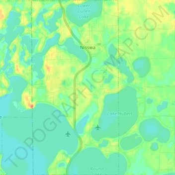
Name: Nisswa topographic map, elevation, terrain.
Location: Nisswa, Crow Wing County, Minnesota, 56468, United States (46.45612 -94.32994 46.54439 -94.26518)
Average elevation: 1,214 ft
Minimum elevation: 1,175 ft
Maximum elevation: 1,306 ft
Crow Wing County trails, hiking, mountain biking, running and outdoor activities
Make a donation
Gear up for your next adventure:
As an Amazon Associate, this site earns from qualifying purchases at no extra cost to you.
Other topographic maps
Click on a map to view its topography, its elevation and its terrain.
Middle Cullen Lake
United States > Minnesota > Crow Wing County > Pequot Lakes
Average elevation: 1,220 ft
Borden Lake
United States > Minnesota > Crow Wing County > Garrison Township
Average elevation: 1,289 ft
Make a donation
Gear up for your next adventure:
As an Amazon Associate, this site earns from qualifying purchases at no extra cost to you.