Geolocate

Cochabamba topographic map

Click on the map to display elevation.

About this map
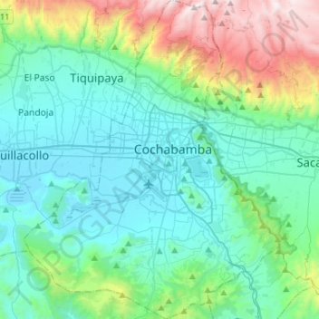
Name: Cochabamba topographic map, elevation, terrain.

Location: Cochabamba, Juan De La Rosa, Molle, Cochabamba, Cercado, Cochabamba, Bolivia (-17.52579 -66.27834 -17.27812 -66.07018)

Average elevation: 9,688 ft

Minimum elevation: 8,317 ft

Maximum elevation: 14,816 ft

Other topographic maps

Click on a map to view its topography, its elevation and its terrain.
Plaza Avaroa

Bolivia > Cochabamba > Cercado > Cochabamba

Average elevation: 8,419 ft

Cochabamba

Bolivia > Cochabamba > Cercado > Cochabamba

Average elevation: 10,318 ft

Gear up for your next adventure:

🌡️Portable Weather Meter - Track weather conditions on the trail
📷Action Camera - Capture your outdoor adventures in HD
🧴Hand Sanitizer - Keep hands clean while hiking
🔋Rechargeable Batteries - Power up your outdoor devices
🌧️Backpack Rain Cover - Keep gear dry in wet weather

As an Amazon Associate, this site earns from qualifying purchases at no extra cost to you.