
Thank you for supporting this site ❤️
Make a donation
Make a donation
Gear up for your next adventure:
As an Amazon Associate, this site earns from qualifying purchases at no extra cost to you.
Kisarawe topographic map
Click on the map to display elevation.
Thank you for supporting this site ❤️
Make a donation
Make a donation
Gear up for your next adventure:
As an Amazon Associate, this site earns from qualifying purchases at no extra cost to you.
About this map
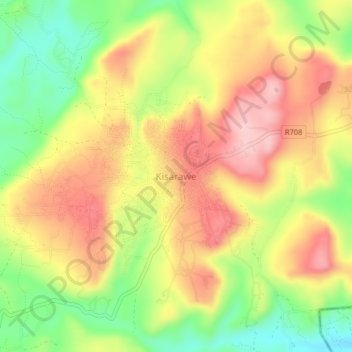
Name: Kisarawe topographic map, elevation, terrain.
Location: Kisarawe, Pwani Region, Coastal Zone, Tanzania (-6.92799 39.05167 -6.88799 39.09167)
Average elevation: 712 ft
Minimum elevation: 374 ft
Maximum elevation: 1,007 ft
Thank you for supporting this site ❤️
Make a donation
Make a donation
Gear up for your next adventure:
As an Amazon Associate, this site earns from qualifying purchases at no extra cost to you.