
Thank you for supporting this site ❤️
Make a donation
Make a donation
Gear up for your next adventure:
As an Amazon Associate, this site earns from qualifying purchases at no extra cost to you.
Crossway topographic map
Click on the map to display elevation.
Thank you for supporting this site ❤️
Make a donation
Make a donation
Gear up for your next adventure:
As an Amazon Associate, this site earns from qualifying purchases at no extra cost to you.
About this map
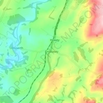
Name: Crossway topographic map, elevation, terrain.
Location: Crossway, Powys, Wales, LD1 5RD, United Kingdom (52.19408 -3.41168 52.23408 -3.37168)
Average elevation: 725 ft
Minimum elevation: 499 ft
Maximum elevation: 1,119 ft
Thank you for supporting this site ❤️
Make a donation
Make a donation
Gear up for your next adventure:
As an Amazon Associate, this site earns from qualifying purchases at no extra cost to you.