Geolocate

Shakopee topographic map

Click on the map to display elevation.

About this map

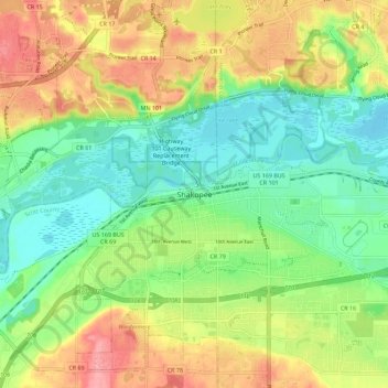
Name: Shakopee topographic map, elevation, terrain.

Location: Shakopee, Scott County, Minnesota, 55379, United States (44.75802 -93.56690 44.83802 -93.48690)

Average elevation: 814 ft

Minimum elevation: 682 ft

Maximum elevation: 1,004 ft

Scott County trails, hiking, mountain biking, running and outdoor activities

Gear up for your next adventure:

📶Vehicle Signal Boosters - Improve reception in rural areas while driving to trailheads
🔊Portable Camp Speaker - Music and alerts at camp
🗺️Topographic Maps - Detailed topo maps for hiking, exploring and outdoor navigation
🔥Fast-Boil Camping Stoves - Efficient cooking systems for quick trail meals
🖼️Topo Map Wall Art - Decorative topographic prints of famous peaks and regions

As an Amazon Associate, this site earns from qualifying purchases at no extra cost to you.