
Make a donation
Gear up for your next adventure:
As an Amazon Associate, this site earns from qualifying purchases at no extra cost to you.
Gaimühle topographic map
Click on the map to display elevation.
Make a donation
Gear up for your next adventure:
As an Amazon Associate, this site earns from qualifying purchases at no extra cost to you.
Gaimühle
Die Kernstadt und die meisten der Ortsteile befinden sich rechtsseitig des Neckars. Neckarwimmersbach (früher nur Wimmersbach, zur Unterscheidung von Waldwimmersbach wie dieses umbenannt), Rockenau und Pleutersbach liegen linksseitig im Knie des von Süden nach Westen abknickenden Neckars im sogenannten Kleinen Odenwald. Neckarwimmersbach liegt direkt am Neckarufer gegenüber der Kernstadt. Es ist seit dem Bau der Neckarbrücke 1899 nach Eberbach eingemeindet und mit diesem zusammengewachsen, so dass der ursprünglich auf einer Anhöhe oberhalb des Neckarufers liegende historische Ortskern von Neckarwimmersbach heute praktisch keine Bedeutung mehr hat.
Make a donation
Gear up for your next adventure:
As an Amazon Associate, this site earns from qualifying purchases at no extra cost to you.
About this map
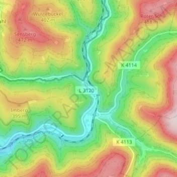
Name: Gaimühle topographic map, elevation, terrain.
Average elevation: 1,053 ft
Minimum elevation: 486 ft
Maximum elevation: 1,759 ft
Make a donation
Gear up for your next adventure:
As an Amazon Associate, this site earns from qualifying purchases at no extra cost to you.
Other topographic maps
Click on a map to view its topography, its elevation and its terrain.