Geolocate

Kachchh topographic map

Interactive map

Click on the map to display elevation.

About this map

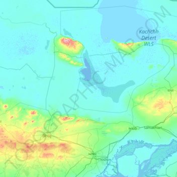
Name: Kachchh topographic map, elevation, terrain.

Location: Kachchh, Bhuj Taluka, Kutch District, Gujarat, India (23.58328 69.99995 23.58338 70.00005)

Average elevation: 10 ft

Minimum elevation: -3 ft

Maximum elevation: 20 ft

Other topographic maps

Click on a map to view its topography, its elevation and its terrain.

Bhuj

India > Gujarat > Bhuj Taluka

Bhuj, Bhuj Taluka, Kachchh, Gujarat, 370001, India

Average elevation: 427 ft

Dhordo

India > Gujarat > Bhuj Taluka

Dhordo, Bhuj Taluka, Kachchh, Gujarat, 370510, India

Average elevation: 13 ft

Sedata

India > Gujarat > Bhuj Taluka

Sedata, Bhuj Taluka, Kachchh, Gujarat, 370427, India

Average elevation: 591 ft

Amrapar (2)

India > Gujarat > Bhuj Taluka

Amrapar (2), Bhuj Taluka, Kachchh, Gujarat, 370165, India

Average elevation: 49 ft