Geolocate

Eldwick topographic map

Click on the map to display elevation.

About this map

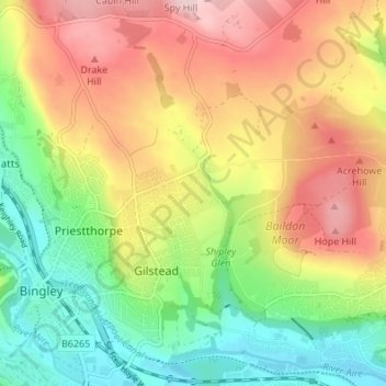
Name: Eldwick topographic map, elevation, terrain.

Location: Eldwick, Bingley, Bradford, West Yorkshire, England, BD16 3NX, United Kingdom (53.83809 -1.83176 53.87809 -1.79176)

Average elevation: 571 ft

Minimum elevation: 213 ft

Maximum elevation: 984 ft

Other topographic maps

Click on a map to view its topography, its elevation and its terrain.

Bingley South Bog

United Kingdom > England > Bradford > Bingley > Cottingley

Average elevation: 374 ft

Myrtle Park

United Kingdom > England > Bradford > Bingley

Average elevation: 413 ft

Gear up for your next adventure:

Solar GPS Watches - Advanced multisport watches with built-in topographic maps
🪶Thermal Camp Blanket - Extra warmth for cold nights
🔊Portable Camp Speaker - Music and alerts at camp
🪶Multi‑Purpose Knife - Useful blade for camp and trail
🥄Camping Utensil Set - Lightweight utensils for outdoor meals

As an Amazon Associate, this site earns from qualifying purchases at no extra cost to you.