
Brockelbank Hill topographic map
Interactive map
Click on the map to display elevation.
About this map
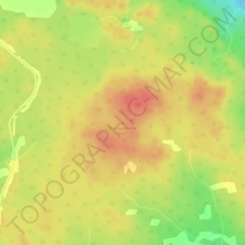
Name: Brockelbank Hill topographic map, elevation, terrain.
Location: Brockelbank Hill, Hudson Bay No. 394, Saskatchewan, Canada (52.62557 -101.77602 52.62567 -101.77592)
Average elevation: 2,612 ft
Minimum elevation: 2,500 ft
Maximum elevation: 2,671 ft
Other topographic maps
Click on a map to view its topography, its elevation and its terrain.
Hudson Bay No. 394
Canada > Saskatchewan > Hudson Bay No. 394
Hudson Bay No. 394, Saskatchewan, Canada
Average elevation: 1,421 ft