Geolocate

Manville topographic map

Click on the map to display elevation.

About this map

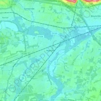
Name: Manville topographic map, elevation, terrain.

Location: Manville, Somerset County, New Jersey, 08835, United States (40.50101 -74.62754 40.58101 -74.54754)

Average elevation: 72 ft

Minimum elevation: 16 ft

Maximum elevation: 394 ft

Gear up for your next adventure:

🪶Thermal Camp Blanket - Extra warmth for cold nights
🧴Hand Sanitizer - Keep hands clean while hiking
🛶Inflatable Kayak - Portable kayak for rivers, lakes, and expeditions
🔭Compact Binoculars - HD vision for scouting terrain and identifying distant landmarks
🗺️Topographic Maps - Detailed topo maps for hiking, exploring and outdoor navigation

As an Amazon Associate, this site earns from qualifying purchases at no extra cost to you.