
Thank you for supporting this site ❤️
Make a donation
Make a donation
Gear up for your next adventure:
As an Amazon Associate, this site earns from qualifying purchases at no extra cost to you.
Viöl topographic map
Click on the map to display elevation.
Thank you for supporting this site ❤️
Make a donation
Make a donation
Gear up for your next adventure:
As an Amazon Associate, this site earns from qualifying purchases at no extra cost to you.
About this map
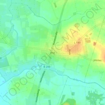
Name: Viöl topographic map, elevation, terrain.
Location: Viöl, Nordfriesland, Schleswig-Holstein, 25884, Deutschland (54.54963 9.15160 54.58963 9.19160)
Average elevation: 36 ft
Minimum elevation: 3 ft
Maximum elevation: 98 ft
Thank you for supporting this site ❤️
Make a donation
Make a donation
Gear up for your next adventure:
As an Amazon Associate, this site earns from qualifying purchases at no extra cost to you.