
Make a donation
Gear up for your next adventure:
As an Amazon Associate, this site earns from qualifying purchases at no extra cost to you.
Brukom topographic map
Click on the map to display elevation.
Make a donation
Gear up for your next adventure:
As an Amazon Associate, this site earns from qualifying purchases at no extra cost to you.
About this map
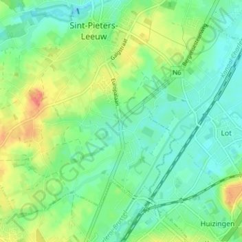
Name: Brukom topographic map, elevation, terrain.
Average elevation: 128 ft
Minimum elevation: 69 ft
Maximum elevation: 236 ft
Make a donation
Gear up for your next adventure:
As an Amazon Associate, this site earns from qualifying purchases at no extra cost to you.
Other topographic maps
Click on a map to view its topography, its elevation and its terrain.
Sint-Pieters-Leeuw
België > Vlaams-Brabant > Halle-Vilvoorde > Sint-Pieters-Leeuw
Sint-Pieters-Leeuw ligt op de oostelijke rand van het Pajottenland op een hoogte van 25-62 meter. De plaats ligt aan de Zuunbeek. De belangrijkste natuurgebieden zijn.
Average elevation: 138 ft
Oudenaken
België > Vlaams-Brabant > Halle-Vilvoorde > Sint-Pieters-Leeuw
Oudenaken ligt in het Pajottenland op een hoogte van 30-57,5 meter. Oudenaken wordt in het zuiden begrensd door de Zuunbeek.
Average elevation: 135 ft
Ruisbroek
België > Vlaams-Brabant > Halle-Vilvoorde > Sint-Pieters-Leeuw
Ruusbroek ligt op een hoogte van 22-25 meter aan de Zenne en het Kanaal Brussel-Charleroi. Door de nabijheid van de Brusselse agglomeratie is de plaats verstedelijkt en wordt ingesloten door infrastructuur (autoweg, HSL-lijn).
Average elevation: 95 ft
Make a donation
Gear up for your next adventure:
As an Amazon Associate, this site earns from qualifying purchases at no extra cost to you.
Vlezenbeek
België > Vlaams-Brabant > Halle-Vilvoorde > Sint-Pieters-Leeuw
Vlezenbeek ligt aan de oostrand van het Pajottenland op een hoogte van 30-80 meter. De plaats ligt te midden van een weids landschap met vierkanthoeven.
Average elevation: 154 ft