Geolocate

Ditton topographic map

Click on the map to display elevation.

About this map

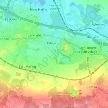
Name: Ditton topographic map, elevation, terrain.

Location: Ditton, Tonbridge and Malling, Kent, England, United Kingdom (51.27119 0.44504 51.31305 0.47107)

Average elevation: 121 ft

Minimum elevation: -10 ft

Maximum elevation: 318 ft

Gear up for your next adventure:

🩹Survival Bandages - High‑quality bandages for emergencies
🔭Compact Binoculars - HD vision for scouting terrain and identifying distant landmarks
🔦Powerful Headlamps - Ultra-bright hands-free lighting for night navigation
🛡️Insect Repellent - Protection against bugs during outdoor activities
🌎3D Topographic Globes - Raised relief globes for a tactile understanding of geography

As an Amazon Associate, this site earns from qualifying purchases at no extra cost to you.