
Oakwood Hills topographic map
Interactive map
Click on the map to display elevation.
About this map
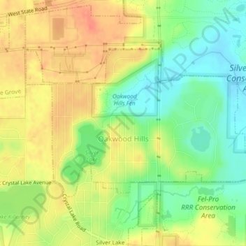
Name: Oakwood Hills topographic map, elevation, terrain.
Location: Oakwood Hills, McHenry County, Illinois, United States (42.24003 -88.25740 42.25619 -88.22119)
Average elevation: 814 ft
Minimum elevation: 732 ft
Maximum elevation: 886 ft
McHenry County trails, hiking, mountain biking, running and outdoor activities
Other topographic maps
Click on a map to view its topography, its elevation and its terrain.
Elizabeth Lake Nature Preserve
United States > Illinois > McHenry County > Twin Lakes
Average elevation: 820 ft