Geolocate

Oroville topographic map

Click on the map to display elevation.

About this map

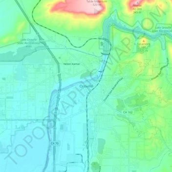
Name: Oroville topographic map, elevation, terrain.

Location: Oroville, Butte County, California, 95965, United States (39.47378 -121.59636 39.55378 -121.51636)

Average elevation: 315 ft

Minimum elevation: 112 ft

Maximum elevation: 1,125 ft

Butte County trails, hiking, mountain biking, running and outdoor activities

Gear up for your next adventure:

🚁Photography Drones - Capture stunning aerial views of landforms and topography
🩹Survival Bandages - High‑quality bandages for emergencies
🥩Freeze-Dried Meals - Nutritious and lightweight food for remote expeditions
🩳Quick‑Dry Hiking Shorts - Comfortable and quick‑dry shorts for summer hiking
📦Dry Bags Set - Waterproof storage for electronics and clothes

As an Amazon Associate, this site earns from qualifying purchases at no extra cost to you.