Geolocate

Dunwoody topographic map

Click on the map to display elevation.

About this map

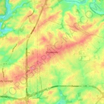
Name: Dunwoody topographic map, elevation, terrain.

Location: Dunwoody, DeKalb County, Georgia, 30338, United States (33.90638 -84.37427 33.98638 -84.29427)

Average elevation: 1,014 ft

Minimum elevation: 810 ft

Maximum elevation: 1,201 ft

DeKalb County trails, hiking, mountain biking, running and outdoor activities

Other topographic maps

Click on a map to view its topography, its elevation and its terrain.

Brook Run Park

United States > Georgia > DeKalb County > Dunwoody

Average elevation: 1,001 ft

Gear up for your next adventure:

🧦Merino Wool Socks - Moisture-wicking, blister-preventing socks for long treks
🌎3D Topographic Globes - Raised relief globes for a tactile understanding of geography
📻Weather Alert Radios - Stay informed of storm risks while off-the-grid
🗺️NatGeo Topo Maps - High-quality waterproof printed topographic maps of US Parks
🧦Hiking Socks - Comfortable socks to prevent blisters on long hikes

As an Amazon Associate, this site earns from qualifying purchases at no extra cost to you.