
At Ḥemṣi topographic map
Interactive map
Click on the map to display elevation.
About this map
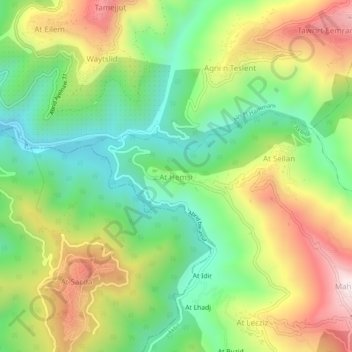
Name: At Ḥemṣi topographic map, elevation, terrain.
Location: At Ḥemṣi, Akbil, Daïra Aïn El Hammam, Tizi Ouzou, 15200, Algérie (36.51943 4.27215 36.55943 4.31215)
Average elevation: 2,251 ft
Minimum elevation: 1,378 ft
Maximum elevation: 3,484 ft
Other topographic maps
Click on a map to view its topography, its elevation and its terrain.
Aït Mislayene
Algérie > Tizi Ouzou > Daïra Aïn El Hammam > Akbil
Aït Mislayene, Akbil, Daïra Aïn El Hammam, Tizi Ouzou, Algérie
Average elevation: 3,091 ft
Akaoudj
Algérie > Tizi Ouzou > Daïra Aïn El Hammam > Akbil > Akaoudj
Akaoudj, Akbil, Daïra Aïn El Hammam, Tizi Ouzou, 15260, Algérie
Average elevation: 3,383 ft