Geolocate

Zemmora topographic map

Click on the map to display elevation.

About this map

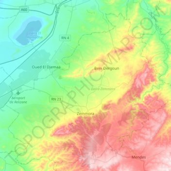
Name: Zemmora topographic map, elevation, terrain.

Location: Zemmora, Zemmora District, Relizane, 48000, Algeria (35.68031 0.60019 35.85006 0.93779)

Average elevation: 837 ft

Minimum elevation: 108 ft

Maximum elevation: 2,156 ft

Gear up for your next adventure:

📖Nature Tracking Books - Learn to track wildlife and terrain
🌲Outdoor Survival Books - Best books on survival skills
🧭Compass with Lanyard - Easy‑carry compass for navigation
⛑️Personal Locator Beacon - Safety beacon for emergencies
🪄Magnetic Compass - Accurate compass for navigation

As an Amazon Associate, this site earns from qualifying purchases at no extra cost to you.