
Make a donation
Gear up for your next adventure:
As an Amazon Associate, this site earns from qualifying purchases at no extra cost to you.
Huizerhoogt topographic map
Click on the map to display elevation.
Make a donation
Gear up for your next adventure:
As an Amazon Associate, this site earns from qualifying purchases at no extra cost to you.
About this map
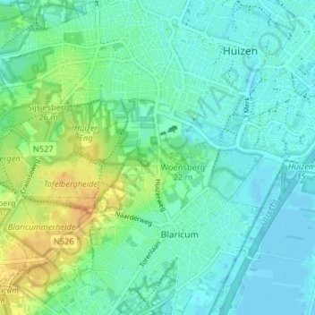
Name: Huizerhoogt topographic map, elevation, terrain.
Average elevation: 30 ft
Minimum elevation: -7 ft
Maximum elevation: 102 ft
Make a donation
Gear up for your next adventure:
As an Amazon Associate, this site earns from qualifying purchases at no extra cost to you.
Other topographic maps
Click on a map to view its topography, its elevation and its terrain.
Tafelbergheide
Nederland > Noord-Holland > Huizen > Huizerhoogt
Het heidegebied kent veel hoogteverschillen, veroorzaakt door het landijs ten tijde van de rissijstijd. Hoogste punt is de Tafelberg waaraan deze heide haar naam heeft te danken. Deze 36,4 meter hoge 'heuvel' is een van de hoogste punten van de provincie Noord-Holland. De naam is ontleend aan een oude…
Average elevation: 52 ft