
Make a donation
Gear up for your next adventure:
As an Amazon Associate, this site earns from qualifying purchases at no extra cost to you.
Abantos topographic map
Click on the map to display elevation.
Make a donation
Gear up for your next adventure:
As an Amazon Associate, this site earns from qualifying purchases at no extra cost to you.
Abantos
Es uno de los más importantes de la sierra de Guadarrama (perteneciente al sistema Central). Tiene una altitud de 1753 metros. La vertiente norte de la montaña está en el valle de Cuelgamuros, mientras que la parte oeste de la cima pertenece a la provincia de Ávila (Castilla y León).
Make a donation
Gear up for your next adventure:
As an Amazon Associate, this site earns from qualifying purchases at no extra cost to you.
About this map
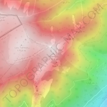
Name: Abantos topographic map, elevation, terrain.
Average elevation: 4,892 ft
Minimum elevation: 3,261 ft
Maximum elevation: 5,758 ft
Make a donation
Gear up for your next adventure:
As an Amazon Associate, this site earns from qualifying purchases at no extra cost to you.
Other topographic maps
Click on a map to view its topography, its elevation and its terrain.
Arboreto Luis Ceballos
España > Comunidad de Madrid > San Lorenzo de El Escorial
Average elevation: 4,298 ft