
Make a donation
Gear up for your next adventure:
As an Amazon Associate, this site earns from qualifying purchases at no extra cost to you.
Linosa topographic map
Click on the map to display elevation.
Make a donation
Gear up for your next adventure:
As an Amazon Associate, this site earns from qualifying purchases at no extra cost to you.
About this map
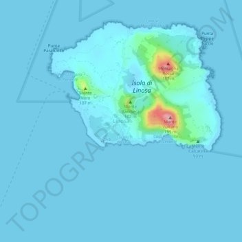
Name: Linosa topographic map, elevation, terrain.
Location: Linosa, Lampedusa e Linosa, Agrigento, Sicily, 92031, Italy (35.83944 12.84327 35.87944 12.88327)
Average elevation: 30 ft
Minimum elevation: 0 ft
Maximum elevation: 600 ft
Make a donation
Gear up for your next adventure:
As an Amazon Associate, this site earns from qualifying purchases at no extra cost to you.
Other topographic maps
Click on a map to view its topography, its elevation and its terrain.
Aragona
Aragona is located on the eastern slopes of the Mount Belvedere at an altitude of 428 m. In the 13th century, the Castello di Barrugeri was built near what is now Aragona, but it no longer exists. The town was founded on 6 January 1606, upon the initiative of lord Baldassare III Naselli, Count of Comiso. He…
Average elevation: 991 ft
Make a donation
Gear up for your next adventure:
As an Amazon Associate, this site earns from qualifying purchases at no extra cost to you.
Make a donation
Gear up for your next adventure:
As an Amazon Associate, this site earns from qualifying purchases at no extra cost to you.
Make a donation
Gear up for your next adventure:
As an Amazon Associate, this site earns from qualifying purchases at no extra cost to you.