
Dodoma topographic map
Interactive map
Click on the map to display elevation.
About this map
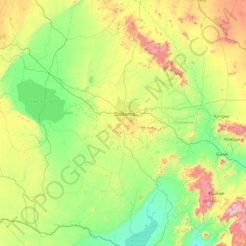
Name: Dodoma topographic map, elevation, terrain.
Location: Dodoma, Central Zone, Tanzania (-7.07153 35.09456 -5.40889 36.26281)
Average elevation: 3,455 ft
Minimum elevation: 2,159 ft
Maximum elevation: 7,631 ft
Other topographic maps
Click on a map to view its topography, its elevation and its terrain.
Kwaheri wilaya ya Chamwino
Kwaheri wilaya ya Chamwino, Dodoma, Central Zone, Tanzania
Average elevation: 3,396 ft