
Make a donation
Gear up for your next adventure:
As an Amazon Associate, this site earns from qualifying purchases at no extra cost to you.
Laguna topographic map
Click on the map to display elevation.
Make a donation
Gear up for your next adventure:
As an Amazon Associate, this site earns from qualifying purchases at no extra cost to you.
Laguna
Laguna is a Brazilian municipality located in the southern state of Santa Catarina, 120 kilometers south of the state's capital, Florianópolis, and north east of Porto Alegre. The population is 46,122 (2020 est.) in an area of 336.4 km². Elevation is 2 m. The BR-101 coastal highway passes through the municipality.
Make a donation
Gear up for your next adventure:
As an Amazon Associate, this site earns from qualifying purchases at no extra cost to you.
About this map
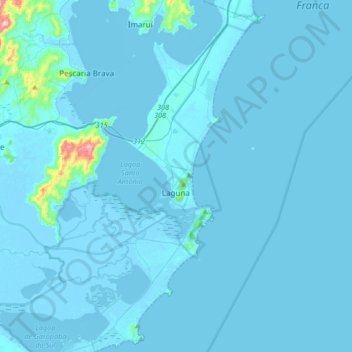
Name: Laguna topographic map, elevation, terrain.
Average elevation: 36 ft
Minimum elevation: -16 ft
Maximum elevation: 1,358 ft
Make a donation
Gear up for your next adventure:
As an Amazon Associate, this site earns from qualifying purchases at no extra cost to you.