
Franskraal se Berg topographic map
Interactive map
Click on the map to display elevation.
About this map
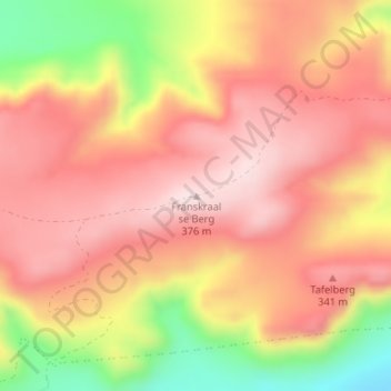
Name: Franskraal se Berg topographic map, elevation, terrain.
Average elevation: 810 ft
Minimum elevation: 56 ft
Maximum elevation: 1,237 ft
Other topographic maps
Click on a map to view its topography, its elevation and its terrain.
Kleinbaai
South Africa > Western Cape > Overberg District Municipality > Overstrand Local Municipality
Kleinbaai, Overstrand Local Municipality, Overberg District Municipality, Western Cape, South Africa
Average elevation: 49 ft
Vermont
South Africa > Western Cape > Overberg District Municipality > Overstrand Local Municipality
Vermont, Overstrand Ward 13, Overstrand Local Municipality, Overberg District Municipality, Western Cape, South Africa
Average elevation: 121 ft
Pringle Bay
South Africa > Western Cape > Overberg District Municipality > Overstrand Local Municipality
Pringle Bay, Overstrand Local Municipality, Overberg District Municipality, Western Cape, South Africa
Average elevation: 203 ft
Baardskeerdersbos
South Africa > Western Cape > Overberg District Municipality > Overstrand Local Municipality
Baardskeerdersbos, Overstrand Ward 11, Overstrand Local Municipality, Overberg District Municipality, Western Cape, 7271, South Africa
Average elevation: 394 ft
Van Dyksbaai
South Africa > Western Cape > Overberg District Municipality > Overstrand Local Municipality
Van Dyksbaai, Overstrand Local Municipality, Overberg District Municipality, Western Cape, South Africa
Average elevation: 46 ft
Pearly Beach
South Africa > Western Cape > Overberg District Municipality > Overstrand Local Municipality
Pearly Beach, Overstrand Ward 11, Overstrand Local Municipality, Overberg District Municipality, Western Cape, South Africa
Average elevation: 36 ft
Danger Point Lighthouse
South Africa > Western Cape > Overberg District Municipality > Overstrand Local Municipality
Danger Point Lighthouse, Marine Drive, Overstrand Ward 2, Overstrand Local Municipality, Overberg District Municipality, Western Cape, South Africa
Average elevation: 20 ft
Pringle Bay Peak
South Africa > Western Cape > Overberg District Municipality > Overstrand Local Municipality
Pringle Bay Peak, Overstrand Local Municipality, Overberg District Municipality, Western Cape, South Africa
Average elevation: 115 ft
Franskraalstrand
South Africa > Western Cape > Overberg District Municipality > Overstrand Local Municipality
Franskraalstrand, Overstrand Ward 1, Overstrand Local Municipality, Overberg District Municipality, Western Cape, South Africa
Average elevation: 95 ft