
Jelenia Góra topographic map
Interactive map
Click on the map to display elevation.
About this map
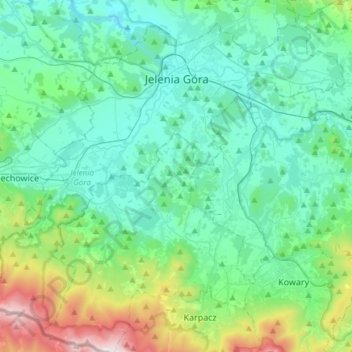
Name: Jelenia Góra topographic map, elevation, terrain.
Location: Jelenia Góra, Lower Silesian Voivodeship, Poland (50.76777 15.57787 50.93256 15.87716)
Average elevation: 1,699 ft
Minimum elevation: 945 ft
Maximum elevation: 4,882 ft
The central suburb of Jelenia Góra possesses many historical and architectural structures of great significance, including the 17th-century Town Hall, baroque churches and a restored central marketplace as well as parks and gardens. The name of the city translates to Deer Mountain in Polish and the original German name due to its geographical and topographical location. The nearby Karkonosze National Park, visited by over 1.5 million tourists annually, has its headquarters in Jelenia Góra.
Other topographic maps
Click on a map to view its topography, its elevation and its terrain.
Karkonosze
Poland > Lower Silesian Voivodeship > Jelenia Góra
Karkonosze, Jelenia Góra, Lower Silesian Voivodeship, Poland
Average elevation: 3,924 ft
Jelenia Góra
Poland > Lower Silesian Voivodeship > Jelenia Góra
Jelenia Góra, Karkonosze County, Lower Silesian Voivodeship, Poland
Average elevation: 1,903 ft