
Make a donation
Gear up for your next adventure:
As an Amazon Associate, this site earns from qualifying purchases at no extra cost to you.
Oaxtepec topographic map
Click on the map to display elevation.
Make a donation
Gear up for your next adventure:
As an Amazon Associate, this site earns from qualifying purchases at no extra cost to you.
Oaxtepec
El Centro Vacacional IMSS Oaxtepec "Adolfo López Mateos", es un complejo turístico y de convenciones de 120 hectáreas, inaugurado el 28 de noviembre de 1964. Está ubicado a 75 minutos de la Ciudad de México, a una altitud de 1360 m (4461′ 11″) sobre el nivel del mar.
Make a donation
Gear up for your next adventure:
As an Amazon Associate, this site earns from qualifying purchases at no extra cost to you.
About this map
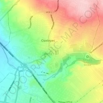
Name: Oaxtepec topographic map, elevation, terrain.
Location: Oaxtepec, Yautepec, Morelos, 62738, México (18.87056 -99.01200 18.95056 -98.93200)
Average elevation: 4,636 ft
Minimum elevation: 4,108 ft
Maximum elevation: 6,099 ft
Make a donation
Gear up for your next adventure:
As an Amazon Associate, this site earns from qualifying purchases at no extra cost to you.