
Make a donation
Gear up for your next adventure:
As an Amazon Associate, this site earns from qualifying purchases at no extra cost to you.
La Réole topographic map
Click on the map to display elevation.
Make a donation
Gear up for your next adventure:
As an Amazon Associate, this site earns from qualifying purchases at no extra cost to you.
About this map
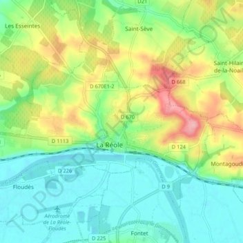
Name: La Réole topographic map, elevation, terrain.
Average elevation: 167 ft
Minimum elevation: 23 ft
Maximum elevation: 443 ft
Make a donation
Gear up for your next adventure:
As an Amazon Associate, this site earns from qualifying purchases at no extra cost to you.
Other topographic maps
Click on a map to view its topography, its elevation and its terrain.
Bordeaux
France > Nouvelle-Aquitaine > Gironde > Bordeaux
La superficie de la commune est de 49,36 km2. Son altitude varie de 1 à 42 mètres
Average elevation: 115 ft
Dune du Pilat
France > Nouvelle-Aquitaine > Gironde > La Teste-de-Buch
La dune du Pilat est une dune située en Gironde (région Nouvelle-Aquitaine) à l'entrée du bassin d'Arcachon, sur la côte d'Argent, en bordure du massif forestier des Landes de Gascogne, dans le sud-ouest de la France. C'est la plus haute dune d’Europe (altitude en 2023 : 103,6 m).
Average elevation: 79 ft
Make a donation
Gear up for your next adventure:
As an Amazon Associate, this site earns from qualifying purchases at no extra cost to you.
Make a donation
Gear up for your next adventure:
As an Amazon Associate, this site earns from qualifying purchases at no extra cost to you.
Les Maréchaux
France > Nouvelle-Aquitaine > Gironde > Saint-Girons-d'Aiguevives
Average elevation: 151 ft
Make a donation
Gear up for your next adventure:
As an Amazon Associate, this site earns from qualifying purchases at no extra cost to you.
Make a donation
Gear up for your next adventure:
As an Amazon Associate, this site earns from qualifying purchases at no extra cost to you.
Make a donation
Gear up for your next adventure:
As an Amazon Associate, this site earns from qualifying purchases at no extra cost to you.
Casse de l'Aygue
France > Nouvelle-Aquitaine > Gironde > Le Pian-Médoc > Sénéjac
Average elevation: 98 ft
Make a donation
Gear up for your next adventure:
As an Amazon Associate, this site earns from qualifying purchases at no extra cost to you.
Make a donation
Gear up for your next adventure:
As an Amazon Associate, this site earns from qualifying purchases at no extra cost to you.
Make a donation
Gear up for your next adventure:
As an Amazon Associate, this site earns from qualifying purchases at no extra cost to you.
Château Brane-Cantenac
France > Nouvelle-Aquitaine > Gironde > Margaux-Cantenac > Ninotte
Average elevation: 46 ft
Make a donation
Gear up for your next adventure:
As an Amazon Associate, this site earns from qualifying purchases at no extra cost to you.
Make a donation
Gear up for your next adventure:
As an Amazon Associate, this site earns from qualifying purchases at no extra cost to you.
Make a donation
Gear up for your next adventure:
As an Amazon Associate, this site earns from qualifying purchases at no extra cost to you.
Make a donation
Gear up for your next adventure:
As an Amazon Associate, this site earns from qualifying purchases at no extra cost to you.
Make a donation
Gear up for your next adventure:
As an Amazon Associate, this site earns from qualifying purchases at no extra cost to you.
Make a donation
Gear up for your next adventure:
As an Amazon Associate, this site earns from qualifying purchases at no extra cost to you.
Make a donation
Gear up for your next adventure:
As an Amazon Associate, this site earns from qualifying purchases at no extra cost to you.
La Borie de Prussi
France > Nouvelle-Aquitaine > Gironde > Saint-Aubin-de-Branne
Average elevation: 171 ft
Make a donation
Gear up for your next adventure:
As an Amazon Associate, this site earns from qualifying purchases at no extra cost to you.
Blanzac Ouest
France > Nouvelle-Aquitaine > Gironde > Lugon-et-l'Île-du-Carnay
Average elevation: 66 ft
Le Grand Monguillet Nord
France > Nouvelle-Aquitaine > Gironde > Listrac-de-Durèze
Average elevation: 282 ft
Make a donation
Gear up for your next adventure:
As an Amazon Associate, this site earns from qualifying purchases at no extra cost to you.
Make a donation
Gear up for your next adventure:
As an Amazon Associate, this site earns from qualifying purchases at no extra cost to you.
Make a donation
Gear up for your next adventure:
As an Amazon Associate, this site earns from qualifying purchases at no extra cost to you.
Make a donation
Gear up for your next adventure:
As an Amazon Associate, this site earns from qualifying purchases at no extra cost to you.
Make a donation
Gear up for your next adventure:
As an Amazon Associate, this site earns from qualifying purchases at no extra cost to you.
Château Lafite-Rothschild
France > Nouvelle-Aquitaine > Gironde > Pauillac > Mousset
Average elevation: 46 ft
Make a donation
Gear up for your next adventure:
As an Amazon Associate, this site earns from qualifying purchases at no extra cost to you.
Saint-Médard-en-Jalles
France > Nouvelle-Aquitaine > Gironde
La première édition du festival CinéDrones est organisée le 10 juillet 2015 au cinéma de Saint-Médard-en-Jalles. C’est la technopole Bordeaux Technowest, très impliquée dans le développement de la filière drones en Aquitaine, qui organise ce festival international de films intégrant des prises de…
Average elevation: 108 ft
Villenave-d'Ornon
France > Nouvelle-Aquitaine > Gironde > Villenave-d'Ornon > Villenave-d'Ornon
Average elevation: 56 ft
La Teste-de-Buch
France > Nouvelle-Aquitaine > Gironde > La Teste-de-Buch > La Teste-de-Buch
Average elevation: 39 ft
Saint-Jean-d'Illac
France > Nouvelle-Aquitaine > Gironde > Saint-Jean-d'Illac > Saint-Jean-d'Illac
Average elevation: 151 ft
Make a donation
Gear up for your next adventure:
As an Amazon Associate, this site earns from qualifying purchases at no extra cost to you.
Gujan-Mestras
France > Nouvelle-Aquitaine > Gironde > Gujan-Mestras > Gujan-Mestras
En 1803, les autres municipalités du département durent envoyer à la préfecture une étude sur la topographie, l’agriculture, l’industrie de sa commune, ainsi que sur l’état des habitants. À ce moment-là, cette étude regroupa deux quartiers que sont Gujan et Mestras sous le nom de commune Gujan.…
Average elevation: 16 ft
Ambarès-et-Lagrave
France > Nouvelle-Aquitaine > Gironde > Ambarès-et-Lagrave > Ambarès-et-Lagrave
Average elevation: 46 ft
Saint-Émilion
France > Nouvelle-Aquitaine > Gironde > Saint-Émilion > Saint-Émilion
Average elevation: 157 ft
Make a donation
Gear up for your next adventure:
As an Amazon Associate, this site earns from qualifying purchases at no extra cost to you.
Parc du Château Feydeau
France > Nouvelle-Aquitaine > Gironde > Artigues-près-Bordeaux
Average elevation: 197 ft
Make a donation
Gear up for your next adventure:
As an Amazon Associate, this site earns from qualifying purchases at no extra cost to you.