
Make a donation
Gear up for your next adventure:
As an Amazon Associate, this site earns from qualifying purchases at no extra cost to you.
Stump Sound topographic map
Click on the map to display elevation.
Make a donation
Gear up for your next adventure:
As an Amazon Associate, this site earns from qualifying purchases at no extra cost to you.
About this map
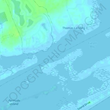
Name: Stump Sound topographic map, elevation, terrain.
Location: Stump Sound, Onslow County, North Carolina, United States (34.48012 -77.48196 34.48022 -77.48186)
Average elevation: 3 ft
Minimum elevation: -10 ft
Maximum elevation: 30 ft
Onslow County trails, hiking, mountain biking, running and outdoor activities
Make a donation
Gear up for your next adventure:
As an Amazon Associate, this site earns from qualifying purchases at no extra cost to you.
Other topographic maps
Click on a map to view its topography, its elevation and its terrain.
Marine Corps Base Camp Lejeune
United States > North Carolina > Onslow County
Average elevation: 23 ft
Onslow Beach
United States > North Carolina > Onslow County > Marine Corps Base Camp Lejeune
Average elevation: 7 ft
Make a donation
Gear up for your next adventure:
As an Amazon Associate, this site earns from qualifying purchases at no extra cost to you.