
Thank you for supporting this site ❤️
Make a donation
Make a donation
Gear up for your next adventure:
As an Amazon Associate, this site earns from qualifying purchases at no extra cost to you.
Monte Acquaviva topographic map
Click on the map to display elevation.
Thank you for supporting this site ❤️
Make a donation
Make a donation
Gear up for your next adventure:
As an Amazon Associate, this site earns from qualifying purchases at no extra cost to you.
About this map
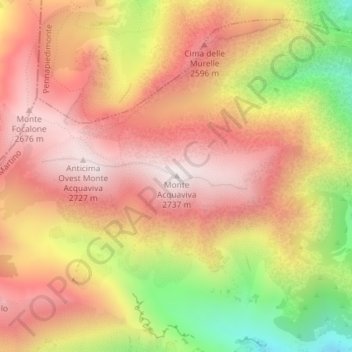
Name: Monte Acquaviva topographic map, elevation, terrain.
Location: Monte Acquaviva, Fara San Martino, Chieti, Abruzzo, Italia (42.10206 14.13024 42.10216 14.13034)
Average elevation: 7,812 ft
Minimum elevation: 6,010 ft
Maximum elevation: 8,970 ft
Thank you for supporting this site ❤️
Make a donation
Make a donation
Gear up for your next adventure:
As an Amazon Associate, this site earns from qualifying purchases at no extra cost to you.