
Pasil topographic map
Click on the map to display elevation.
About this map
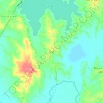
Name: Pasil topographic map, elevation, terrain.
Location: Pasil, Ilocos Norte, Ilocos Region, 2902, Philippines (18.08090 120.51987 18.12090 120.55987)
Average elevation: 89 ft
Minimum elevation: 10 ft
Maximum elevation: 269 ft
Other topographic maps
Click on a map to view its topography, its elevation and its terrain.
Pagudpud
The town's topography includes mountains, hills, valleys and flat coastal land.
Average elevation: 233 ft
La Paz Sand Dunes
Philippines > Ilocos Norte > Brgy. 62-B Navotas South > Laoag
Average elevation: 23 ft
Pagudpud
The town's topography includes mountains, hills, valleys and flat coastal land.
Average elevation: 240 ft