
Make a donation
Gear up for your next adventure:
As an Amazon Associate, this site earns from qualifying purchases at no extra cost to you.
Klausdorf topographic map
Click on the map to display elevation.
Make a donation
Gear up for your next adventure:
As an Amazon Associate, this site earns from qualifying purchases at no extra cost to you.
About this map
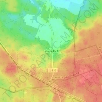
Name: Klausdorf topographic map, elevation, terrain.
Average elevation: 299 ft
Minimum elevation: 197 ft
Maximum elevation: 374 ft
Make a donation
Gear up for your next adventure:
As an Amazon Associate, this site earns from qualifying purchases at no extra cost to you.
Other topographic maps
Click on a map to view its topography, its elevation and its terrain.
Feldheim
Deutschland > Brandenburg > Potsdam-Mittelmark > Treuenbrietzen
Der Ortsteil Feldheim und Schwabeck liegt auf einer sogenannten Fläming-Hochfläche auf etwa 150 Metern Höhe. Die Hochfläche steigt insgesamt leicht in Richtung Norden und Nordwesten an. Das heutige Oberflächenprofil wurde durch die Endmoränenbildungen des Warthestadiums der Saalevereisung entscheidend…
Average elevation: 430 ft
Make a donation
Gear up for your next adventure:
As an Amazon Associate, this site earns from qualifying purchases at no extra cost to you.