
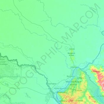
José Falcón topographic map
Interactive map
Click on the map to display elevation.
About this map
Name: José Falcón topographic map, elevation, terrain.
Location: José Falcón, Presidente Hayes, Región Occidental, Paraguay (-25.27014 -58.50207 -24.68955 -57.64361)
Average elevation: 243 ft
Minimum elevation: 161 ft
Maximum elevation: 892 ft
Located in the Western region of Paraguay, in the area of Paraguayan Chaco. Its physical appearance is part of the characteristics of the Chaco soil: lowland with abundant vegetation of palm trees. It is a coastal city located at the junction between the Pilcomayo and Paraguay rivers. This district is located in a lowland area with clay soil. With no meaningful elevations. The geography in general at this part of the department is characterized by being swampy, with palm trees and grasses. It is a region that is highly prone to flooding in the rainy seasons of the year.
Other topographic maps
Click on a map to view its topography, its elevation and its terrain.
Colonia 96
Colonia 96, Presidente Hayes, Región Occidental, Paraguay
Average elevation: 259 ft
San Francisco
Paraguay > Presidente Hayes > San Francisco
San Francisco, Presidente Hayes, Región Occidental, 9800, Paraguay
Average elevation: 240 ft