
Make a donation
Gear up for your next adventure:
As an Amazon Associate, this site earns from qualifying purchases at no extra cost to you.
Ittenhausen topographic map
Click on the map to display elevation.
Make a donation
Gear up for your next adventure:
As an Amazon Associate, this site earns from qualifying purchases at no extra cost to you.
About this map
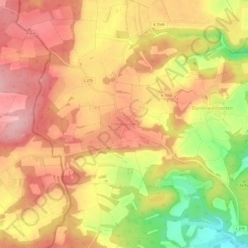
Name: Ittenhausen topographic map, elevation, terrain.
Average elevation: 2,464 ft
Minimum elevation: 2,139 ft
Maximum elevation: 2,657 ft
Make a donation
Gear up for your next adventure:
As an Amazon Associate, this site earns from qualifying purchases at no extra cost to you.
Other topographic maps
Click on a map to view its topography, its elevation and its terrain.
Riedlingen
Deutschland > Baden-Württemberg > Landkreis Biberach
Die erste Ortszelle der NSDAP bildete sich 1930 und bestand hauptsächlich aus Lehrern des Gymnasiums. Im März 1933 erreichte die NSDAP bei den Reichstagswahlen 36 Prozent der Stimmen. Am 1. April kam es zum ersten von SA-Männern überwachten Boykott der jüdischen Geschäfte nach einem Aufruf der…
Average elevation: 1,962 ft
88441
Deutschland > Baden-Württemberg > Landkreis Biberach > Mittelbiberach
Average elevation: 1,906 ft
Make a donation
Gear up for your next adventure:
As an Amazon Associate, this site earns from qualifying purchases at no extra cost to you.
Kirchdorf an der Iller
Deutschland > Baden-Württemberg > Landkreis Biberach
Average elevation: 1,854 ft
Achstetten
Deutschland > Baden-Württemberg > Landkreis Biberach > Achstetten
Die Wahlbeteiligung bei der Kommunalwahl 2019 lag bei 64,6 % und war damit um 5,6 Prozentpunkte höher als bei der Kommunalwahl 2014.
Average elevation: 1,660 ft
Make a donation
Gear up for your next adventure:
As an Amazon Associate, this site earns from qualifying purchases at no extra cost to you.