Geolocate

Cann topographic map

Click on the map to display elevation.

About this map

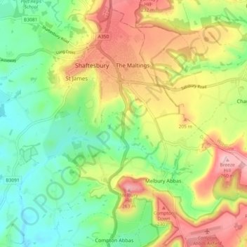
Name: Cann topographic map, elevation, terrain.

Location: Cann, Dorset, England, United Kingdom (50.97738 -2.24728 51.00678 -2.15628)

Average elevation: 499 ft

Minimum elevation: 223 ft

Maximum elevation: 883 ft

Other topographic maps

Click on a map to view its topography, its elevation and its terrain.

Fontmell Down

United Kingdom > England > Dorset > Fontmell Magna

Average elevation: 512 ft

Morcombelake

United Kingdom > England > Dorset

Average elevation: 243 ft

Wareham

United Kingdom > England > Dorset

Average elevation: 52 ft

St Ives

United Kingdom > England > Dorset

Average elevation: 79 ft

Muckleford

United Kingdom > England > Dorset > Grimstone

Average elevation: 374 ft

Burning Cliff

United Kingdom > England > Dorset > South Holworth

Average elevation: 210 ft

Ridge

United Kingdom > England > Dorset > Wareham > Ridge

Average elevation: 23 ft

Castletown

United Kingdom > England > Dorset

Average elevation: 59 ft

Chiswell

United Kingdom > England > Dorset

Average elevation: 79 ft

Mount Ararat

United Kingdom > England > Dorset > Verwood

Average elevation: 197 ft

Gear up for your next adventure:

🔋Rechargeable Batteries - Power up your outdoor devices
❄️Traction Cleats - Prevent slips on icy trails during winter hikes
🥄Camping Utensil Set - Lightweight utensils for outdoor meals
📶Vehicle Signal Boosters - Improve reception in rural areas while driving to trailheads
🏫Relief Map Kits - Hands-on tools for teaching landforms and elevation

As an Amazon Associate, this site earns from qualifying purchases at no extra cost to you.