Geolocate

Valmadonna topographic map

Click on the map to display elevation.

👉 Easily get elevation data in JSON, GeoTIFF and KML formats using Elevation API
Thank you for supporting this site ❤️
Make a donation

About this map

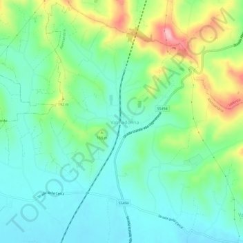
Name: Valmadonna topographic map, elevation, terrain.

Location: Valmadonna, Alessandria, Piedmont, 15048, Italy (44.95104 8.59174 44.99104 8.63174)

Average elevation: 479 ft

Minimum elevation: 312 ft

Maximum elevation: 866 ft

Gear up for your next adventure:

📱Solar Portable Charger - Solar power bank for charging devices off‑grid
🧢Sun Protection Hats - Wide-brimmed and UPF-rated hats for high-altitude sun safety
🔪Outdoor Multitools - Essential survival tools for gear repair and field use
🧤Tactile Hiking Gloves - Keep hands warm while operating GPS and smartphone screens
🌐World Map Poster - Decorative world maps with topographic info

As an Amazon Associate, this site earns from qualifying purchases at no extra cost to you.