
Failand topographic map
Interactive map
Click on the map to display elevation.
About this map
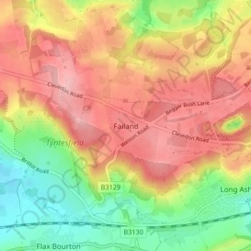
Name: Failand topographic map, elevation, terrain.
Location: Failand, North Somerset, England, BS8 3UH, United Kingdom (51.42022 -2.71151 51.46022 -2.67151)
Average elevation: 325 ft
Minimum elevation: 59 ft
Maximum elevation: 554 ft
Other topographic maps
Click on a map to view its topography, its elevation and its terrain.
Portishead
United Kingdom > England > North Somerset
Portishead, North Somerset, England, United Kingdom
Average elevation: 79 ft
East Dundry
United Kingdom > England > North Somerset > Dundry
East Dundry, Dundry, North Somerset, England, BS41 8NH, United Kingdom
Average elevation: 390 ft