Geolocate

Eassie topographic map

Interactive map

Click on the map to display elevation.

About this map

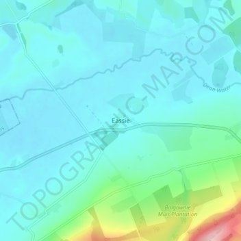
Name: Eassie topographic map, elevation, terrain.

Location: Eassie, Angus, Scotland, DD8 1SG, United Kingdom (56.59363 -3.07774 56.63363 -3.03774)

Average elevation: 240 ft

Minimum elevation: 148 ft

Maximum elevation: 778 ft

Other topographic maps

Click on a map to view its topography, its elevation and its terrain.

Brechin

United Kingdom > Scotland > Angus

Brechin, Angus, Scotland, DD9 6ET, United Kingdom

Average elevation: 233 ft

Montrose

United Kingdom > Scotland > Angus

Montrose, Angus, Scotland, DD10 8QW, United Kingdom

Average elevation: 72 ft

Bridgefoot

United Kingdom > Scotland > Angus

Bridgefoot, Angus, Scotland, DD3 0TA, United Kingdom

Average elevation: 410 ft

Fern

United Kingdom > Scotland > Angus

Fern, Angus, Scotland, DD8 3QW, United Kingdom

Average elevation: 512 ft

Padanaram

United Kingdom > Scotland > Angus > Padanaram

Padanaram, Angus, Scotland, DD8 1PT, United Kingdom

Average elevation: 223 ft

Coe

United Kingdom > Scotland > Angus > Balhall > Coe

Coe, Balhall, Angus, Scotland, DD9 6SF, United Kingdom

Average elevation: 371 ft