
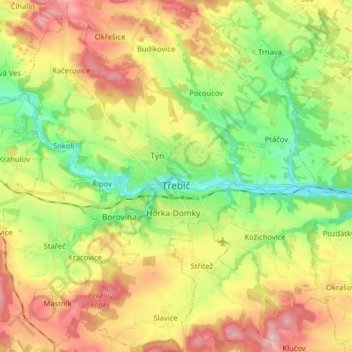
Třebíč topographic map
Interactive map
Click on the map to display elevation.
About this map
Name: Třebíč topographic map, elevation, terrain.
Average elevation: 1,572 ft
Minimum elevation: 1,266 ft
Maximum elevation: 1,955 ft
Třebíč is situated 35 kilometres (22 mi) southeast of Jihlava and 65 kilometres (40 mi) west of Brno. It lies in the Jevišovice Uplands within the Bohemian-Moravian Highlands. The town is located the Jihlava River. The highest point in the municipal territory has an elevation of 579 metres (1,900 ft) above sea level.
Other topographic maps
Click on a map to view its topography, its elevation and its terrain.
Lány
Czechia > Southeast > Kraj Vysočina
Lány, okres Havlíčkův Brod, Kraj Vysočina, Southeast, Czechia
Average elevation: 1,539 ft
Nové Město na Moravě
Czechia > Southeast > Kraj Vysočina
Nové Město na Moravě, okres Žďár nad Sázavou, Kraj Vysočina, Southeast, 592 31, Czechia
Average elevation: 2,149 ft
Pávov
Czechia > Southeast > Kraj Vysočina > Jihlava
Pávov, Jihlava, okres Jihlava, Kraj Vysočina, Southeast, 588 11, Czechia
Average elevation: 1,722 ft
Křídla
Czechia > Southeast > Kraj Vysočina > Křídla
Křídla, okres Žďár nad Sázavou, Kraj Vysočina, Southeast, Czechia
Average elevation: 1,969 ft
Popůvky
Czechia > Southeast > Kraj Vysočina > Popůvky
Popůvky, okres Třebíč, Kraj Vysočina, Southeast, Czechia
Average elevation: 1,444 ft
Radostín nad Oslavou
Czechia > Southeast > Kraj Vysočina
Radostín nad Oslavou, okres Žďár nad Sázavou, Kraj Vysočina, Southeast, 594 44, Czechia
Average elevation: 1,808 ft
Strážek
Czechia > Southeast > Kraj Vysočina
Strážek, okres Žďár nad Sázavou, Kraj Vysočina, Southeast, 592 53, Czechia
Average elevation: 1,660 ft