
Thank you for supporting this site ❤️
Make a donation
Make a donation
Gear up for your next adventure:
As an Amazon Associate, this site earns from qualifying purchases at no extra cost to you.
Lány topographic map
Click on the map to display elevation.
Thank you for supporting this site ❤️
Make a donation
Make a donation
Gear up for your next adventure:
As an Amazon Associate, this site earns from qualifying purchases at no extra cost to you.
About this map
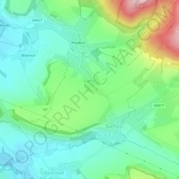
Name: Lány topographic map, elevation, terrain.
Location: Lány, okres Havlíčkův Brod, Kraj Vysočina, Southeast, Czechia (49.74917 15.70105 49.76682 15.72994)
Average elevation: 1,539 ft
Minimum elevation: 1,322 ft
Maximum elevation: 2,067 ft
Thank you for supporting this site ❤️
Make a donation
Make a donation
Gear up for your next adventure:
As an Amazon Associate, this site earns from qualifying purchases at no extra cost to you.
Other topographic maps
Click on a map to view its topography, its elevation and its terrain.