
Make a donation
Gear up for your next adventure:
As an Amazon Associate, this site earns from qualifying purchases at no extra cost to you.
Tarata topographic map
Click on the map to display elevation.
Make a donation
Gear up for your next adventure:
As an Amazon Associate, this site earns from qualifying purchases at no extra cost to you.
Tarata
El municipio tiene una topografía variada: el norte forma parte del valle alto, con una altura promedia de 2800 m.s.n.m., mientras que la parte sur forma parte de serranías con una altura máxima de 3.360 m.s.n.m. (Pico Pucara), bajando a la cuenca del Río Caine (2250 m.s.n.m.).
Make a donation
Gear up for your next adventure:
As an Amazon Associate, this site earns from qualifying purchases at no extra cost to you.
About this map
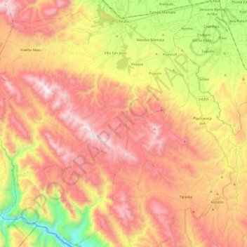
Name: Tarata topographic map, elevation, terrain.
Location: Tarata, Esteban Arze, Cochabamba, Bolivia (-17.82080 -66.17910 -17.59199 -65.95925)
Average elevation: 9,898 ft
Minimum elevation: 7,352 ft
Maximum elevation: 11,942 ft
Make a donation
Gear up for your next adventure:
As an Amazon Associate, this site earns from qualifying purchases at no extra cost to you.
Other topographic maps
Click on a map to view its topography, its elevation and its terrain.