
十八台镇 topographic map
Interactive map
Click on the map to display elevation.
About this map
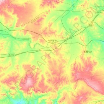
Name: 十八台镇 topographic map, elevation, terrain.
Location: 十八台镇, 卓资县, 乌兰察布市, 内蒙古自治区, 中国 (40.73649 112.65811 41.00429 112.95444)
Average elevation: 5,282 ft
Minimum elevation: 4,610 ft
Maximum elevation: 6,122 ft
Other topographic maps
Click on a map to view its topography, its elevation and its terrain.