Geolocate

Ariza topographic map

Click on the map to display elevation.

About this map

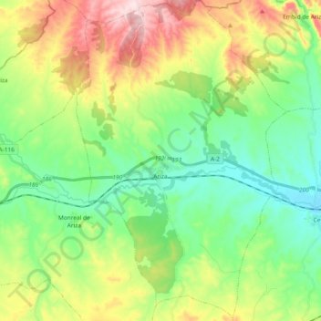
Name: Ariza topographic map, elevation, terrain.

Location: Ariza, Comunidad de Calatayud, Zaragoza, Aragon, 50220, Spain (41.24778 -2.10432 41.38684 -1.98233)

Average elevation: 2,628 ft

Minimum elevation: 2,205 ft

Maximum elevation: 3,432 ft

Other topographic maps

Click on a map to view its topography, its elevation and its terrain.

Solana

Spain > Aragon > Comunidad de Calatayud > Calatayud

Average elevation: 2,867 ft

Pico Agudo

Spain > Aragon > Comunidad de Calatayud > Codos

Average elevation: 3,159 ft

Valderoy

Spain > Aragon > Comunidad de Calatayud > Ateca

Average elevation: 2,162 ft

Gear up for your next adventure:

🧦Hiking Socks - Comfortable socks to prevent blisters on long hikes
🪶Paracord Bracelet - Survival bracelet with built‑in tools
🧤Hiking Gloves - Protective gloves for rugged trails
🎒Outdoor Daypacks - Lightweight backpacks designed for carrying maps and essential gear
🦶Hiking Gaiters - Keep debris and water out of your boots

As an Amazon Associate, this site earns from qualifying purchases at no extra cost to you.