
Make a donation
Gear up for your next adventure:
As an Amazon Associate, this site earns from qualifying purchases at no extra cost to you.
Beldorf topographic map
Click on the map to display elevation.
Make a donation
Gear up for your next adventure:
As an Amazon Associate, this site earns from qualifying purchases at no extra cost to you.
Beldorf
Beldorf wurde 1447 erstmals erwähnt, damals noch als „Beltorppe“. Eine mögliche Bedeutung des Ortsnamens könnte „Dorf bei der Anhöhe“ sein.
Make a donation
Gear up for your next adventure:
As an Amazon Associate, this site earns from qualifying purchases at no extra cost to you.
About this map
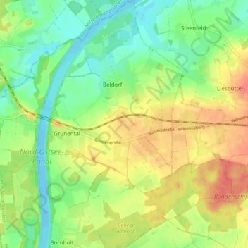
Name: Beldorf topographic map, elevation, terrain.
Average elevation: 79 ft
Minimum elevation: -7 ft
Maximum elevation: 177 ft
Make a donation
Gear up for your next adventure:
As an Amazon Associate, this site earns from qualifying purchases at no extra cost to you.
Other topographic maps
Click on a map to view its topography, its elevation and its terrain.
Make a donation
Gear up for your next adventure:
As an Amazon Associate, this site earns from qualifying purchases at no extra cost to you.
Schülp
Deutschland > Schleswig-Holstein > Rendsburg-Eckernförde > Schülp bei Rendsburg
Average elevation: 16 ft
Make a donation
Gear up for your next adventure:
As an Amazon Associate, this site earns from qualifying purchases at no extra cost to you.
Kopperpahl
Deutschland > Schleswig-Holstein > Rendsburg-Eckernförde > Kronshagen > Kopperpahl
Average elevation: 69 ft
Nortorf
Deutschland > Schleswig-Holstein > Rendsburg-Eckernförde > Nortorf > Nortorf
Average elevation: 82 ft
Büdelsdorf
Deutschland > Schleswig-Holstein > Rendsburg-Eckernförde > Büdelsdorf > Büdelsdorf
Average elevation: 33 ft
Hanerau-Hademarschen
Deutschland > Schleswig-Holstein > Rendsburg-Eckernförde
Average elevation: 92 ft
Make a donation
Gear up for your next adventure:
As an Amazon Associate, this site earns from qualifying purchases at no extra cost to you.
Holtdorf
Deutschland > Schleswig-Holstein > Rendsburg-Eckernförde > Bargstedt
Average elevation: 115 ft
Kronsburg
Deutschland > Schleswig-Holstein > Rendsburg-Eckernförde > Bredenbek
Average elevation: 56 ft
Lurup
Deutschland > Schleswig-Holstein > Rendsburg-Eckernförde > Elsdorf-Westermühlen
Average elevation: 46 ft
Schweineweide
Deutschland > Schleswig-Holstein > Rendsburg-Eckernförde > Damp
Average elevation: 13 ft
Make a donation
Gear up for your next adventure:
As an Amazon Associate, this site earns from qualifying purchases at no extra cost to you.
Domsland
Deutschland > Schleswig-Holstein > Rendsburg-Eckernförde > Eckernförde
Average elevation: 69 ft
Klein Nordsee
Deutschland > Schleswig-Holstein > Rendsburg-Eckernförde > Felde
Average elevation: 46 ft
Make a donation
Gear up for your next adventure:
As an Amazon Associate, this site earns from qualifying purchases at no extra cost to you.
Make a donation
Gear up for your next adventure:
As an Amazon Associate, this site earns from qualifying purchases at no extra cost to you.
Make a donation
Gear up for your next adventure:
As an Amazon Associate, this site earns from qualifying purchases at no extra cost to you.
Make a donation
Gear up for your next adventure:
As an Amazon Associate, this site earns from qualifying purchases at no extra cost to you.
Hohenhain
Deutschland > Schleswig-Holstein > Rendsburg-Eckernförde > Schwedeneck
Average elevation: 66 ft
Make a donation
Gear up for your next adventure:
As an Amazon Associate, this site earns from qualifying purchases at no extra cost to you.
Hörst
Deutschland > Schleswig-Holstein > Rendsburg-Eckernförde > Rieseby > Hörst
Average elevation: 89 ft
Make a donation
Gear up for your next adventure:
As an Amazon Associate, this site earns from qualifying purchases at no extra cost to you.
Kronshagen
Deutschland > Schleswig-Holstein > Rendsburg-Eckernförde > Kronshagen > Kronshagen
Average elevation: 72 ft
Bargfeld
Deutschland > Schleswig-Holstein > Rendsburg-Eckernförde > Bargfeld
Average elevation: 102 ft
Make a donation
Gear up for your next adventure:
As an Amazon Associate, this site earns from qualifying purchases at no extra cost to you.