
Make a donation
Gear up for your next adventure:
As an Amazon Associate, this site earns from qualifying purchases at no extra cost to you.
Palabong topographic map
Click on the map to display elevation.
Make a donation
Gear up for your next adventure:
As an Amazon Associate, this site earns from qualifying purchases at no extra cost to you.
About this map
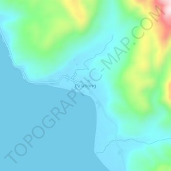
Name: Palabong topographic map, elevation, terrain.
Location: Palabong, New Ireland, Islands Region, Papua New Guinea (-3.96774 152.54275 -3.92774 152.58275)
Average elevation: 315 ft
Minimum elevation: 0 ft
Maximum elevation: 1,808 ft
Make a donation
Gear up for your next adventure:
As an Amazon Associate, this site earns from qualifying purchases at no extra cost to you.
Other topographic maps
Click on a map to view its topography, its elevation and its terrain.
New Ireland
Papua New Guinea > New Ireland
The island is part of two ecoregions. The New Britain-New Ireland lowland rain forests extend from sea level to 1000 meters elevation. The New Britain-New Ireland montane rain forests cover the mountains of New Ireland above 1000 meters elevation.
Average elevation: 272 ft