
Ponta do Campo topographic map
Click on the map to display elevation.
About this map
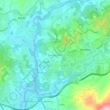
Name: Ponta do Campo topographic map, elevation, terrain.
Location: Ponta do Campo, Gondar, Guimarães, Braga, 4835-551, Portugal (41.40524 -8.38861 41.44524 -8.34861)
Average elevation: 486 ft
Minimum elevation: 272 ft
Maximum elevation: 1,293 ft
Other topographic maps
Click on a map to view its topography, its elevation and its terrain.
Rio Ave
Portugal > Braga > Guimarães > Gondar
O Ave é um rio português, que nasce na serra da Cabreira, município de Vieira do Minho, a cerca de 1200 m de altitude. Percorre cerca de 91 km e desagua no oceano Atlântico, a sul de Vila do Conde. A sua bacia hidrográfica tem uma área aproximada de 1390 km², abrangendo 15 municípios. O rio banha…
Average elevation: 430 ft