
Bultfontein topographic map
Click on the map to display elevation.
About this map
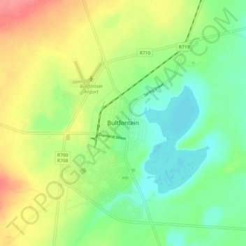
Name: Bultfontein topographic map, elevation, terrain.
Average elevation: 4,350 ft
Minimum elevation: 4,255 ft
Maximum elevation: 4,491 ft
Other topographic maps
Click on a map to view its topography, its elevation and its terrain.
Bloemhof Dam
South Africa > Free State > Lejweleputswa District Municipality > Tswelopele Local Municipality
Average elevation: 4,104 ft
Bloemhof Dam
South Africa > Free State > Lejweleputswa District Municipality > Tswelopele Local Municipality
Average elevation: 4,029 ft
Tswelopele Ward 5
South Africa > Free State > Lejweleputswa District Municipality > Tswelopele Local Municipality
Average elevation: 4,249 ft