
Thank you for supporting this site ❤️
Make a donation
Make a donation
Gear up for your next adventure:
As an Amazon Associate, this site earns from qualifying purchases at no extra cost to you.
Galmihorn topographic map
Click on the map to display elevation.
Thank you for supporting this site ❤️
Make a donation
Make a donation
Gear up for your next adventure:
As an Amazon Associate, this site earns from qualifying purchases at no extra cost to you.
About this map
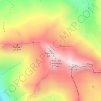
Name: Galmihorn topographic map, elevation, terrain.
Location: Galmihorn, Obergoms, Conches, Valais, 3999, Suisse (46.49834 8.38354 46.49844 8.38364)
Average elevation: 8,248 ft
Minimum elevation: 5,945 ft
Maximum elevation: 9,882 ft
Thank you for supporting this site ❤️
Make a donation
Make a donation
Gear up for your next adventure:
As an Amazon Associate, this site earns from qualifying purchases at no extra cost to you.