
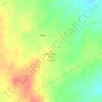
Antelope Peak topographic map
Interactive map
Click on the map to display elevation.
About this map
Name: Antelope Peak topographic map, elevation, terrain.
Location: Antelope Peak, Carson County, Texas, United States (35.59111 -101.56939 35.59121 -101.56929)
Average elevation: 3,291 ft
Minimum elevation: 3,196 ft
Maximum elevation: 3,383 ft
Other topographic maps
Click on a map to view its topography, its elevation and its terrain.
Panhandle
United States > Texas > Carson County
Panhandle, Carson County, Texas, United States
Average elevation: 3,461 ft
Groom
United States > Texas > Carson County > Groom
Groom, Carson County, Texas, United States
Average elevation: 3,271 ft