Geolocate

Jaufen topographic map

Click on the map to display elevation.

About this map

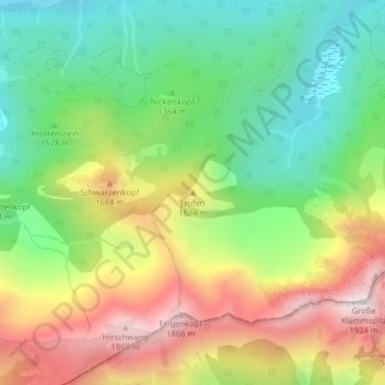
Name: Jaufen topographic map, elevation, terrain.

Location: Jaufen, Halblech, Landkreis Ostallgäu, Bavaria, Germany (47.58819 10.89151 47.58829 10.89161)

Average elevation: 4,656 ft

Minimum elevation: 3,540 ft

Maximum elevation: 6,214 ft

Gear up for your next adventure:

😴Insulated Sleeping Pads - Compact and warm pads for high-elevation camping
🌡️Handheld Weather Meters - Measure wind, temp, and pressure for safe mountain travel
📱Heavy-Duty Phone Cases - Drop-proof and waterproof protection for outdoor navigation
🪶Paracord Bracelet - Survival bracelet with built‑in tools
Solar GPS Watches - Advanced multisport watches with built-in topographic maps

As an Amazon Associate, this site earns from qualifying purchases at no extra cost to you.