
Make a donation
Gear up for your next adventure:
As an Amazon Associate, this site earns from qualifying purchases at no extra cost to you.
Santa María Xonacatepec topographic map
Click on the map to display elevation.
Make a donation
Gear up for your next adventure:
As an Amazon Associate, this site earns from qualifying purchases at no extra cost to you.
About this map
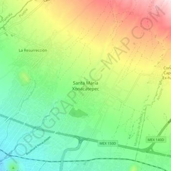
Name: Santa María Xonacatepec topographic map, elevation, terrain.
Average elevation: 7,733 ft
Minimum elevation: 7,231 ft
Maximum elevation: 8,576 ft
Make a donation
Gear up for your next adventure:
As an Amazon Associate, this site earns from qualifying purchases at no extra cost to you.
Other topographic maps
Click on a map to view its topography, its elevation and its terrain.
Biblioteca Central Poniente
México > Puebla > Municipio de Puebla > Puebla de Zaragoza > Universidades
Average elevation: 6,978 ft
Laguna de san Baltazar
México > Puebla > Municipio de Puebla > Puebla de Zaragoza
Average elevation: 6,965 ft
Zona Histórica de los Fuertes
México > Puebla > Municipio de Puebla > Puebla de Zaragoza
Average elevation: 7,149 ft
Ecoparque Metropolitano
México > Puebla > Municipio de Puebla > Puebla de Zaragoza
Average elevation: 6,913 ft
Make a donation
Gear up for your next adventure:
As an Amazon Associate, this site earns from qualifying purchases at no extra cost to you.
Parque Ecológico Revolución Mexicana
México > Puebla > Municipio de Puebla > Puebla de Zaragoza
Average elevation: 7,041 ft
Parque de Analco
México > Puebla > Municipio de Puebla > Puebla de Zaragoza
Average elevation: 7,047 ft
Paseo de Gigantes
México > Puebla > Municipio de Puebla > Puebla de Zaragoza
Average elevation: 7,028 ft
Make a donation
Gear up for your next adventure:
As an Amazon Associate, this site earns from qualifying purchases at no extra cost to you.
Fuerte de Loreto
México > Puebla > Municipio de Puebla > Puebla de Zaragoza
Average elevation: 7,139 ft